![](/images/other/stat-length.png)
![Trail Walking Peyre en Aubrac - Tour aubrac 7j - Photo](https://media.geolcdn.com/t/1900/400/ext.pjpeg?maxdim=2&url=https%3A%2F%2Fstatic1.geolcdn.com%2Fsiteimages%2Fupload%2Ffiles%2F1553511878bg_sport_marche.png)
Tour aubrac 7j
pngt
User
![Length](/images/other/stat-length.png)
Length
142 km
![Max alt](https://static1.geolcdn.com/siteimages/upload/files/1508320355ic_sort_altitude_max_24dp.png)
Max alt
1419 m
![Uphill gradient](https://static1.geolcdn.com/siteimages/upload/files/1508320355ic_sort_den_pos_24dp.png)
Uphill gradient
3430 m
![Km-Effort](/images/other/stat-length.png)
Km-Effort
188 km
![Min alt](https://static1.geolcdn.com/siteimages/upload/files/1508320355ic_sort_altitude_min_24dp.png)
Min alt
792 m
![Downhill gradient](https://static1.geolcdn.com/siteimages/upload/files/1508320355ic_sort_den_neg_24dp.png)
Downhill gradient
3411 m
![Boucle](https://static1.geolcdn.com/siteimages/upload/files/16400158638029165_repeat_loop_refresh_sync_direction_icon.png)
Boucle
Yes
Creation date :
2016-07-05 00:00:00.0
Updated on :
2016-07-05 00:00:00.0
![Walking](https://static1.geolcdn.com/sitytour/trail-icons/101.png)
5m
Difficulty : Easy
![Scan this QR Code to open this trail in the SityTrail application](https://capi.geolives.com/qq0zvz2zws4bq2lad0pu/sitytour/trails/439087/qr.png?size=200)
FREE GPS app for hiking
About
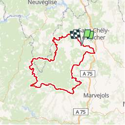
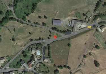
Trail Walking of 142 km to be discovered at Occitania, Lozère, Peyre en Aubrac. This trail is proposed by pngt.
Description
Aumont aubrac - ST laurent Muret (gite crasseux) - Rajas (tente)- ST Chély (gite)- Station Laguiole (tente) - Brion (tente)- Termes (hotel)-Aumont Aubrac
Positioning
Country:
France
Region :
Occitania
Department/Province :
Lozère
Municipality :
Peyre en Aubrac
Location:
Fau-de-Peyre
Start:(Dec)
Start:(UTM)
516757 ; 4955634 (31T) N.
Comments
Trails nearby
![Trail Walking Peyre en Aubrac - Lasbros - Photo](https://media.geolcdn.com/t/375/260/c0f2421e-e54c-492c-b4c7-7d17496731f8.jpg&format=jpg&maxdim=2)
![Walking Walking](https://static1.geolcdn.com/sitytour/trail-icons/101.png)
Lasbros
Walking
Very easy
Peyre en Aubrac,
Occitania,
Lozère,
France
![](/images/other/stat-length.png)
9.7 km | 12.2 km-effort
2h 7min
![](https://static1.geolcdn.com/siteimages/upload/files/16400158638029165_repeat_loop_refresh_sync_direction_icon.png)
Yes
![Trail Walking Termes - Termes Aumont aubrac - Photo](https://media.geolcdn.com/t/375/260/f87d16b1-1f73-4a88-8df5-61d0347ec4b8.jpg&format=jpg&maxdim=2)
![Walking Walking](https://static1.geolcdn.com/sitytour/trail-icons/101.png)
Termes Aumont aubrac
Walking
Medium
Termes,
Occitania,
Lozère,
France
![](/images/other/stat-length.png)
19.1 km | 23 km-effort
7h 22min
![](https://static1.geolcdn.com/siteimages/upload/files/16400158638029165_repeat_loop_refresh_sync_direction_icon.png)
No
![Trail Walking Peyre en Aubrac - les moulins? - Photo](https://media.geolcdn.com/t/375/260/2e35156a-9dac-4c6e-b0c4-947bc48e0da2.jpg&format=jpg&maxdim=2)
![Walking Walking](https://static1.geolcdn.com/sitytour/trail-icons/101.png)
les moulins?
Walking
Difficult
Peyre en Aubrac,
Occitania,
Lozère,
France
![](/images/other/stat-length.png)
12.4 km | 16.3 km-effort
3h 30min
![](https://static1.geolcdn.com/siteimages/upload/files/16400158638029165_repeat_loop_refresh_sync_direction_icon.png)
Yes
![Trail Walking La Fage-Montivernoux - Le Truc de l'Homme- Montivernoux - mercredi - Photo](https://media.geolcdn.com/t/375/260/21d60878-1ada-4ca6-acac-19a6f6979286.png&format=jpg&maxdim=2)
![Walking Walking](https://static1.geolcdn.com/sitytour/trail-icons/101.png)
Le Truc de l'Homme- Montivernoux - mercredi
Walking
Difficult
La Fage-Montivernoux,
Occitania,
Lozère,
France
![](/images/other/stat-length.png)
10.8 km | 13.8 km-effort
3h 8min
![](https://static1.geolcdn.com/siteimages/upload/files/16400158638029165_repeat_loop_refresh_sync_direction_icon.png)
Yes
![Trail Walking Peyre en Aubrac - BOUCLE AU DEPART DE FAU DE PEYRE - Photo](https://media.geolcdn.com/t/375/260/67558f4e-6ab8-4298-8271-3d525e009a1d.jpg&format=jpg&maxdim=2)
![Walking Walking](https://static1.geolcdn.com/sitytour/trail-icons/101.png)
BOUCLE AU DEPART DE FAU DE PEYRE
Walking
Medium
Peyre en Aubrac,
Occitania,
Lozère,
France
![](/images/other/stat-length.png)
18.1 km | 23 km-effort
4h 49min
![](https://static1.geolcdn.com/siteimages/upload/files/16400158638029165_repeat_loop_refresh_sync_direction_icon.png)
Yes
![Trail Cycle Peyre en Aubrac - 240418_j2_4 - Photo](https://media.geolcdn.com/t/375/260/ext.jpg?maxdim=2&url=https%3A%2F%2Fstatic1.geolcdn.com%2Fsiteimages%2Fupload%2Ffiles%2F1524743154velo.jpg)
![Cycle Cycle](https://static1.geolcdn.com/sitytour/trail-icons/200.png)
240418_j2_4
Cycle
Very easy
Peyre en Aubrac,
Occitania,
Lozère,
France
![](/images/other/stat-length.png)
38 km | 46 km-effort
Unknown
![](https://static1.geolcdn.com/siteimages/upload/files/16400158638029165_repeat_loop_refresh_sync_direction_icon.png)
Yes
![Trail Walking Peyre en Aubrac - Fau de Peyre- les moulins (long) - mardi - Photo](https://media.geolcdn.com/t/375/260/ext.jpg?maxdim=2&url=https%3A%2F%2Fstatic1.geolcdn.com%2Fsiteimages%2Fupload%2Ffiles%2F1553511878bg_sport_marche.png)
![Walking Walking](https://static1.geolcdn.com/sitytour/trail-icons/101.png)
Fau de Peyre- les moulins (long) - mardi
Walking
Very difficult
Peyre en Aubrac,
Occitania,
Lozère,
France
![](/images/other/stat-length.png)
14.8 km | 19.5 km-effort
4h 26min
![](https://static1.geolcdn.com/siteimages/upload/files/16400158638029165_repeat_loop_refresh_sync_direction_icon.png)
Yes
![Trail Equestrian La Fage-Saint-Julien - aubrac 2017 - jour 1 pm - Photo](https://media.geolcdn.com/t/375/260/ext.jpg?maxdim=2&url=https%3A%2F%2Fstatic1.geolcdn.com%2Fsiteimages%2Fupload%2Ffiles%2F1524743154cheval.jpg)
![Equestrian Equestrian](https://static1.geolcdn.com/sitytour/trail-icons/300.png)
aubrac 2017 - jour 1 pm
Equestrian
Very easy
La Fage-Saint-Julien,
Occitania,
Lozère,
France
![](/images/other/stat-length.png)
18.2 km | 23 km-effort
2h 51min
![](https://static1.geolcdn.com/siteimages/upload/files/16400158638029165_repeat_loop_refresh_sync_direction_icon.png)
No
![Trail Motor Les Bessons - Parcours quad 02 - Photo](https://media.geolcdn.com/t/375/260/ext.jpg?maxdim=2&url=https%3A%2F%2Fstatic1.geolcdn.com%2Fsiteimages%2Fupload%2Ffiles%2F15247431544x4.jpg)
![Motor Motor](https://static1.geolcdn.com/sitytour/trail-icons/400.png)
Parcours quad 02
Motor
Difficult
Les Bessons,
Occitania,
Lozère,
France
![](/images/other/stat-length.png)
17.5 km | 22 km-effort
56min
![](https://static1.geolcdn.com/siteimages/upload/files/16400158638029165_repeat_loop_refresh_sync_direction_icon.png)
Yes